We awoke to a beautiful clear day as the ship was approaching the harbor in the city of Santa Cruz de La Palma. The sunrise was spectacular, and the winds and seas were calm.

Sunrise in La Palma as Ferryboat Approaches
We ate breakfast, and then loaded up the backpacks for our tour of the volcanoes. Since this was a hiking tour, we were not sure exactly what the weather would be. It was supposed to be warmer today in the city, but we were concerned it might be cooler at the volcanoes. In addition, this was a rain or shine tour, so we had to be prepared and take our rain jackets.
We could not get a definitive answer from the tour desk on what the provision was for eating lunch, so we took some extra croissants from the breakfast bar, along with some ham and some cheese. We used this to make a few sandwiches to take for the hike, and we also grabbed a few bananas for energy. Then we filled our water bottles, put on sunscreen, and were ready to go. We met in the ship’s lounge, and waited for our tour group to be called. We found out that there were only 19 people on the tour, a good small number.
We departed the ship at about 8:45 am, and headed to our tour bus. Our driver was Pepe, and our tour director was David. David was German, and he made his living doing various hikes on the island. La Palma is well known for its vast array of hiking trails, so the hiking guide business must be pretty good. David was not his real German name, but it was his middle name (or the English equivalent) and he used it because he said we would not be able to pronounce his real first name.
We took a 50 minute bus ride from the port to the southern part of the island. Santa Cruz was on the northern side, and that side of the island gets a fair amount of rain. The volcanoes were on the south end of the island, where it is drier. We saw a lot of banana plants, and bananas are the number one export of La Palma. As we headed south, the terrain became more rocky, and drier, and the main crop grown in this region is grapes for making wine. The grape vines grow right on top of the volcanic soil, they are not held up on wires or rope supports like a normal vineyard. We also went through some of the forest that had recently been burned in a forest fire. There were many acres of burned trees. Fortunately, the trees are similar to the giant redwoods in California, they both have very thick bark, which protects them from the heat of the fires. These pines were about the diameter of a normal southern pine, but a lot shorter, and more bushy. We could already see the new growth sprouting on the trees, but David indicated it would take 10 years for the forest to completely recover. It was theorized that the fire started form some fireworks shot off for a party in one of the small towns, but no one was able to confirm that as the cause. There was a lot of damage, and it was sad to see. Apparently, the pines are a vital part of the ecosystem, they actually condense the cloud moisture as the clouds pass over the tall mountains, and that moisture drips off of the needles and onto the ground. This is the primary way moisture falls, there is typically not a lot of normal rainfall, and this is why the pines were so valuable to the ecosystem.
As we approached the southern coast, we were able to see the volcanoes, and I must say we were not initially impressed. They appeared to be small, and were not at a very high elevation like the Mt. Teide volcano in Tenerife. It was not until we watched a movie at the visitor’s center that we realize why these volcanoes were on this end of the island, near to the coast. These were the youngest of the volcanoes on La Palma, and this part of the island has been subjected to quite a few volcanoes over the past 500 years. The last volcano to erupt was the Teneguia Volcano in 1971. This was one of the craters we were going to visit on the hike. The other was the San Antonio Volcano, which has not erupted in 3,200 years, and was the location of the visitor’s center.

On The Rim – San Antonio Volcano
We initially hiked up to the top of the crater for the San Antonio Volcano, and looked down into the crater, it was much larger than it had looked when we had initially seen it upon our arrival. There is just barren volcanic material, very few trees, so there is just no scale to see how big it really was.

On The Rim – San Antonio Volcano
From the viewing area at the rim of the crater, our guide David explained how we were going to hike to the next crater, which we could see, and then from there to the lighthouse at the coast to visit a salt producing facility. It was published to be a 6.5 km. hike, but everyone thought it looked farther.
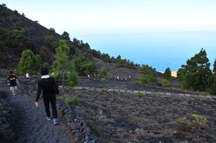
We started down hill on a trail of volcanic pebbles and rock. The trail was fairly steep, and the loose volcanic gravel made it quite slippery at times. It took a little while to get used to the constant slipping, but it got easier as we went.

Heading Down The Trail to Tenenguia
It had turned out to be a beautiful day, not too hot, with just a slight breeze. David commented on the fact that it was usually a lot windier, which would have made it a lot dustier. We had decided to leave the rain gear in the bus, there was not going to be any chance of rain today.
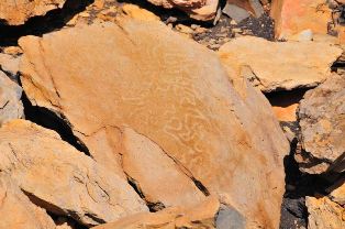
The overall hike was estimated to take about 3.5 hours, with a few stops to look at items, and to get an explanation of the various types of lava, and some information on the volcanoes. The total hiking distance was estimated to be about 7 to 8 kilometers. We went by an area of the original mountain that had not been enveloped in the last eruption. On these original rock outcroppings were some pictographs made by the original inhabitants of the islands.

Ancient Pictographs
In addition to the pictographs, the rocks were inhabited by hundreds of small lizards, some reaching about eight or nine inches in length. Apparently they were not afraid of hikers, and are frequently treated to bananas and cookies. They were funny to watch, they would run right up to where we were standing and take off with a mouthful of food. Some of them would even eat from your hands.

Teneguia Volcano Crater
We hiked a little farther to the Teneguia Volcano, which was the last volcano to erupt on La Palma in 1971. We went right up to the rim of the crater, and actually walked inside of the rime for a short distance. David showed us several small vent holes where heat continuously comes out. It was not extremely hot, but definitely hotter than the normal surrounding air.

Hikers on the Teneguia Volcano Crater Rim
The terrain around the rim of this volcano was very rocky, and the rocks were very sharp. We had to be extra careful not to stumble and fall. There were also a lot of large boulders that had been thrown out of the volcano during the eruption. David had informed us that this volcano had also erupted in 1949, but neither that eruption, nor the one in 1971 had been catastrophic or violent. People did not even really evacuate from the nearby towns.
We left that volcano and continued our hike down to the coast, and to the lighthouse. There were areas where it was reddish brown color, and rocky. Other areas were covered with a finer black material, and there were even some bushes and shrubs growing out of that material. Finally, we made it all the way down to the coast.

Coast of La Palma – Southern End of Island
It had been a more difficult hike that we had expected, mainly due to the gravel consistency of the material, it was just slippery underfoot. You could not look and walk at the same time, the trails were full of protruding rocks that could easily catch your foot, and down you would go.

Salt Refinery and Lighthouse – La Palma
Once at the lighthouse, we went over to an area where the sea water is naturally evaporated to make salt for the island’s consumption, none of it is exported. There were several holding ponds that were used to evaporate the sea water, and the brine solution flowed from one chamber to the next, by gravity, until they were at the smallest size ponds. Then the drying salt was manually pulled out of the highly concentrated solution, and formed into piles of salt crystals. It was collected, and put into bags for distribution, and no additives are introduced.
It was back to the waiting bus for our one hour ride back to the ship. Along the way, David gave us some information and history of the island, which was very interesting. He also explained about how the grapes are grown, and what types of wines are made from them. I do not think he had a lot of attention, almost all of the hikers were dozing after the long day on the trails.
As we approached the northern end of the island, the cloud cover increased, which David said was typical of the weather there. It is cloudy in the afternoon on most days as the sea breeze is condensed by the tall mountains. Once off of the tour bus, we went into the town to look around. We were able to find a grocery store, and bought two bottles of the locally made red wine. We also bought another bottle of a Spanish red wine. We bought one bottle of the cheapest wine available, euro 1.04. This was going to be our sacrificial decoy for getting the other bottles through security. There were also some box wines for the whopping price of euro 0.74. Stephanie wanted to buy some, but we decided our backpacks were full, and we did not want to press our luck in trying the new security bypass technique for the other bottles.

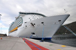
Ship in the Santa Cruz de La Palma Harbor
We looked around in the stores, and then headed back to the ship on the free shuttle bus from town to the pier. Departure time for today was scheduled for 5:00 pm. Stephanie went through the security while I went to take pictures of the ship at the pier.

Navigator of the Seas in La Palma
The plan for going through security involved being in the middle of a bus load of excursion returnees, adding pressure to the security to get everyone through and onto the ship. Usually, everyone is tired and wants to get on the ship with a minimum of effort and hassle, so being in the middle of the crowd usually helps when dealing with contraband! The plan worked like a charm, Stephanie was singled out, along with another bag on the screening at the same time. Off she went to declare the one bottle of sacrificial wine, and then to was off to the cabin with the others we really wanted.
We got back to the cabin and found we were covered in black dust from the hike. After cleaning up, we waited on the balcony for the ship to depart. There was apparently some issue with a computer, either on the ship, or in the port, having to do with paperwork needed for the ship to depart. It took about two hours for it to get straightened out, and we finally left port to start the transatlantic crossing. For the next 6 days, we will be at sea covering the 3,200 miles across the Atlantic Ocean to Nassau, Bahamas.
We went to dinner, this time in the regular dining room. Afterward, we attended an Elton John impersonator performance in the ship’s main theater. He was really good, looked like Elton John, sounded a lot like him, and could play the piano very well. We both thoroughly enjoyed the show. We then called it a night, both of us being tired from the volcano hike. We are both looking forward to sleeping in tomorrow, the past three mornings have been early wake ups at 6:00 am getting ready for the port stops.
Tomorrow is a relaxing day at sea!