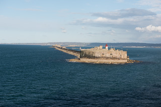
Today’s port stop is in Cherbourg, France. This is our first port since the Azores. Although we did not have any additional time adjustments last night, we still had to get up early today in order to be ready for getting off of the ship at 8:00 AM. We had been good last night and not stayed out late in order to get a good nights rest, but for some reason, neither of us slept that well. We were not sure if it was going to bed so much earlier, the food we ate last night, worrying about getting up on time this morning, or all of the above.
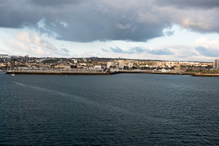
Approaching Cherbourg Harbor
We had set the automated wake up call for 6:15 AM, which would give us enough time to shower, eat a light breakfast and pack our gear for the disembarkation at 8:00 AM. While Stephanie was getting ready, I went down to the International Cafe to get two yogurt parfaits with granola, and some croissants, well a croissant for Stephanie and a blueberry pastry for me. We ate these for breakfast in the room knowing it was faster than going to the buffet with the rest of the passengers.
We had been watching the progress of the ship’s arrival, docking tying up from the balcony. The port staff had to raise up ramps with a crane, so that took a long time to set up, and they were not ready for passengers to disembark at the scheduled time of 8:00 AM. The “natives” on the ship, including us, were getting restless. We had a full day planned, and losing time at the beginning was not helping ease our nerves of getting to and from all of our destinations and be back to the ship on time. Plus, they never want to extend the time in port unless it is a long delay, so they were still announcing the original 5:30 PM all aboard time.
Finally, at about 8:30 AM, they started letting everyone off the ship and, once ashore, we started walking into town to get our rental car from Enterprise. We were docked at the closest in pier to the town center, so it was not a long walk other than getting around the railroad tracks. We ended up only one block off from where we needed to be initially, but soon we were at the car rental office. We tried to go inside but the door was locked. The sign on the door said 8:00 AM for the daily opening time. We could not see inside at first, but then we saw someone coming to the door to open it up. We guess that they were either keeping it locked for security, or for some other reason.
Once inside, we filled out the paper work for the car rental and headed outside with the representative to get our car, a Toyota Yaris, which was parked out on the street. Once we did an inspection of the car for damage and initialed all of the forms we were ready to head out. The representative showed us the road we needed to go on for the drive to the D-Day beaches, and tried to point out the nearest gas station.
We had the GPS up and running in the time it took to adjust the mirrors and seats, and headed out. We were heading to Ponte Du Hoc first, which was where the Army Rangers scaled up about 100 feet of the cliffs to get to the German gun positions there.
We did not get far before we made a wrong turn. The GPS showed us the way to go, but the streets and traffic lights were different from what we have in the USA. There are red straight/turn arrows, left turn arrows and right turn arrows, and the streets are not that well marked for turning lanes, so we ended up in a left turn lane instead of the go straight, right turn lane, which has a different stoplight. We tried to just go around the block, but there was a lot of traffic on one of the side streets. In addition, we ended up in a right turn or straight only intersection, and we needed to go left to get back on the original route. Confusing to say the least. We turned right, then turned into a parking lot so we could go back to the left. After a 10 minute delay, and quite a bit of frustration by the driver, me, we were once again on our way, now wiser on what to look for on the lanes.
It was about an hour’s drive to Ponte Du Hoc. We still do not entirely understand our GPS, or at least how it works in Europe. Somehow, once we exited the main highway, following the GPS directions, we turned right about the time we saw a sign indicating Ponte Du Hoc to the left. We went ahead with the GPS route, but ended up on some really small farm roads. We got there without difficulty, but certainly this was not the route the tour buses took, the roads were really narrow.
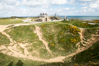
Ponte Du Hoc Craters From Shelling
We had checked the GPS settings and it was on “quickest route” We had difficulty before on a previous GPS with roads in Germany, and had thought it was set to “shortest route”. We still can’t figure out the difference in these two settings, but the “quickest route” still took us on small roads, not sure how, they were too small to go fast on, but did not appear to have any speed limits. Maybe this is how the GPS calculates “quickest”, there are no speed limits, so it is quicker.
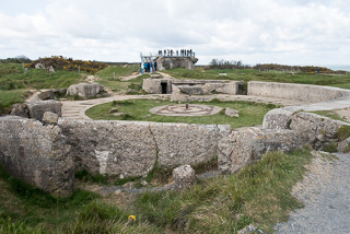
Damaged Gun Emplacements
We parked at Ponte Du Hoc, and went into the small museum/visitors center to get a brochure. It was an interesting area, there were still all of the craters made from Naval shelling during the invasion, and a couple of fortified gun emplacements that had been damaged, some more than others.
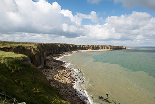
Coastline At Ponte Du Hoc
It was quite a large area of the coast, and of course, was high up from the water. There were not a lot of other visitors there, but there were a lot of school children obviously out on field trips. This was to be the theme of the day, we saw field trip school groups everywhere we stopped, and of varying ages.
We were there about an hour, and then got back into the car for our next stop, Omaha Beach. The first stop at Omaha Beach was to see the monument that was built in the sand some years ago.
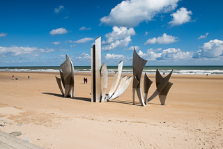
Monument At Omaha Beach
We stopped for some pictures out on the beach. The beach by the monument was pretty flat in comparison to Ponte Du Hoc. By the way, did we mention it was cold and windy. It was only about 45 degrees, and although sunny most of the time, it was very windy.
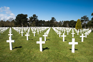
American Cemetery At Omaha Beach
Next stop was the Normandy American Cemetery near Omaha Beach. It was very impressive in a somber way. There are 9,387 American soldiers buried there, everyone who died from the duration of the invasion, which started on June 6, and lasted several months. Each grave has a white marble cross, or Star of David, depending on their religion, with the person’s name, rank, and date of death. We did not actually see many deaths dated from June 6. Most were afterward. We did actually see one from June 4, so we surmised this person was killed during training or some other aspect of the preparation for June 6. We also saw a lot of unnamed markers, apparently some of those killed could not be identified. We even saw several markers from South Carolinians killed in the invasion.
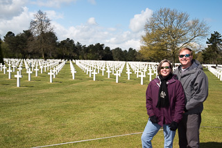
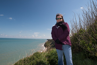
Chuck & Stephanie At The American Cemetery
It was a really humbling experience, it was such a large cemetery, built right along the coast. The grounds were immaculate, and very well maintained. There were also a couple of memorials built on the grounds to commemorate all of those killed in the name of freedom.
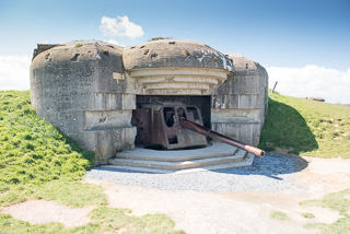
Intact Coastal Guns At Longues-Sur-Mer
We returned to the car and then headed to the German Gun Battery of Longues-Sur-Mer. There were several large reinforced concrete gun batteries there, and several of the 150mm guns are still in the bunkers. These were situated between Omaha and Gold Beaches. Of course, there were about six buses of school kids there, but luckily, they were all eating lunch out on the grass.
This was our farthest point away from Cherbourg to visit with the amount of time we had for our port stop. You could easily spend several days visiting all of the beaches and museums that were part of the D-Day invasion. This was just a small, quick sampling, but we were glad we had done it.
Coastline at Longues-Sur-Mer
We started back toward Cherbourg, taking a route to Utah Beach, which was the other American Invasion site. There was not a lot there to see, and they were doing some clean-up of sand from all of the winter storms.
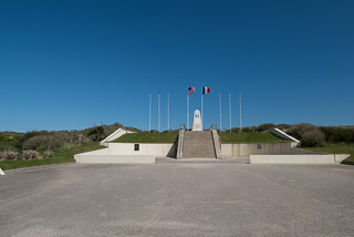
Utah Beach Monument
There was a visitor’s center and museum, but we just did not have the time to visit inside. We took some photos out on the beach, and then got back in the car to head to the nearby town of Sainte-Mere-Eglise, which was where the 82nd and 101st Airborne Divisions were parachuted in to take over the town. It is most famous for the parachutist name John Steele dangled by his parachute from the church.
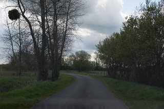
Narrow French Country Roads
Of course, the GPS routed us the “back-way”, taking us on the smallest roads yet, right through farm land and very small French Villages. It was scenic, but made for a stressful drive for me, I could not enjoy the view trying to make sure I saw anyone that might be coming the other way. There was not enough room to pass unless someone went off of the road. Luckily, it was only about 12 km, and we did not see anyone else the entire time.
When we got to Sainte-Mere-Eglise
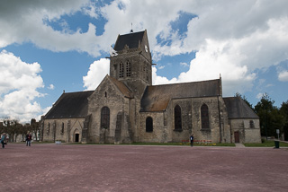
Church At Sainte-Mere-Eglise
we had to pay for parking, the first time we had to pay to park all day. It was a machine that only took small coins and credit cards. It was difficult, there were only graphic instructions, so it took a couple of tries before we got our ticket from the machine to place on the dash showing we had paid.
We visited the church, which still has a replica of John Steel and his hanging parachute draped from the side of the steeple. It had gotten cloudy, so the pictures were not that great.
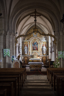
Inside Sainte-Mere-Eglise Church
We decided to get a quick bite to eat at a small restaurant across the street from the church. We really wanted take out, but that was not an option. We ordered a hot ham and cheese sandwich, which took forever to get to us even though we were the only ones there. We had to sit at a table, and when we got the sandwich we saw why it had taken so long. It was grilled, but had melted cheese on the top heated in an oven. It was very good, even though it took longer to get than we wanted. By this time, the sun had come out so were were able to get some nice pictures of the church.
We put in the address of the Enterprise rental car office into the GPS, and started the drive back to Cherbourg. It was about 45 minutes away, and the roads back we actually all major highways with 110 kph speed limits most of the way. The GPS indicated we would be back by about 4:20 PM, which was past our self proclaimed target time of 4:00 PM. Unfortunately, we ran into quite a lot of traffic as we neared Cherbourg, and we still need to fill the car with gas, and we needed to find a gas station near the car return. We saw one on a side street as we went through an intersection, but it was once again, not an easy “around the block” in the car to get back to it. Their streets are not perpendicular, so it is tricky to get back to something. We actually utilized the GPS, and it routed us back to the gas station, which was in its database.
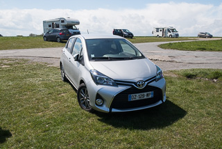
Our Rental Car
We filled the car with gas, totaling Euro 16.50. Gas was about Euro 1.26 per liter. It was now about 4:55 PM, and all aboard time was 5:30 PM, so we were cutting it close, with still a 10-15 minute walk back to the ship from the rental car office. We then headed the few blocks back to the rental car office, but could not find anywhere to park the car in the area we had picked it up, which was just street parking. I double parked while Stephanie went into the office to let them know, and she returned with our representative from this morning who checked us in and all volunteered to drive us back to the ship since we were returning a little late.
Leaving Cherbourg Harbor
We were back at the port in about five minutes, which was nice. We headed to the ship but first stopped in the terminal to sign into the free wi-fi. We did a little email and Facebook, and then boarded the ship at about 5:20 PM. We stopped off at the Crooners Bar for a beverage, it had been a little stressful on the return portion of our trip, and we needed to relax, now that we were back on the ship. In the end, it would not have been an issue, the ship did not leave until about 6:45 PM, it was waiting on a tour group form the ship’s tours that was running late.
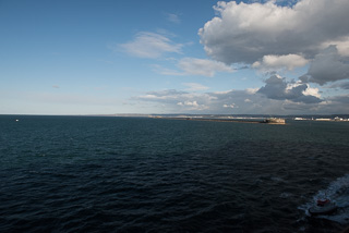
French Coastline
We actually saw a good menu in the dining room, so we headed back to the room to get ready for dinner. Stephanie changed out of her jeans, but I just wore my same outfit from today, which was suitable for the dining room dress code. They had a goat cheese soufflé, which Stephanie really wanted, and grilled scallops, which I wanted. It was nice, we had a good seat near to a window, and since sunset is about 9:40 PM, we had a nice view. The waitstaff was not real busy since it was after 8:00 PM when we arrived, so it was really enjoyable.
We went to Crooners for a nightcap, but knowing that we have another busy port day tomorrow in Zeebrugee, Belgium, we did not stay long. Hopefully we will have a better night’s sleep tonight after our day full of exercise.