After all of yesterday’s problems, we were pleased that today’s weather was bright and sunny when we woke up. Once again, I was up about 6:30 AM to do a little blog work, not quite having finished yesterday’s traumatic post.
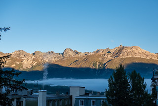
Morning View of the Mountains From Our Balcony
We had a really nice view from our balcony. Looking out to the side, we had a nice view of the nearby mountains with the morning sun shining on the peaks.
We did not really have a detailed plan for today, the research I had done for the main attraction for this stop was for a ride on the Bernina Express, another scenic train ride from Pontresina to Tirano in Italy. We had wanted to wait until we arrived here to make any reservation on the Bernina Express so we could select a good weather day to go. Unfortunately, the weather forecast for the next two days after today calls for a good percentage of rain each day. Today will probably be our only really sunny day in the Pontresina area, and it was too late to take the Bernina Express today since it requires reservations. In addition, there have been some more stringent Covid restrictions put into place for travel into Italy, and we are not even sure we could go all the way to the end on that panoramic train since it ends in Italy. Of course, we might have been able to get off the train before it entered Italy, but the additional complications, along with the weather forecast just made it more difficult than we wanted.
We opted to skip the Bernina Express for this trip and look at a few of the sights around Pontresina today while it was sunny. We were given a transportation pass called the Engadin Card as part of our benefits for staying at the hotel, which we later learned that everyone gets as part of their hotel stays in Pontresina. But it was still nice to have, it covers quite a spectrum of trains, buses and cable car/gondola rides in the entire region, which is called Engadin.
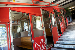
The Muottas Mural Funicular
We had been given several maps of scenic areas and various cable cars when we checked in, and one area, called Muottas Mural was just one train stop from Pontresina. We loaded up our gear and walked down to the train station, which takes about 12 minutes. Luckily, it is all downhill, unlike our walk up from the station yesterday.
The only problem we were having is that the trains only run hourly, so missing a train connection causes a lot of wasted time waiting on the next one. We actually made a timely connection for the one stop train ride to Muottas Mural. Muottas Mural is a funicular, which is a two train rail system that uses cables just above the tracks to propel the trains. As one train goes up, the other comes down, acting as a counterweight. They pass briefly in the middle on split tracks, but the remainder of the time, each car is on the same single track.

Passing the other Train
We just needed to scan our Engadin Cards at the turnstile since it fully covered the ride, and we were allowed to pass and board the funicular.
The ride up was pretty steep, in one section, Stephanie said the brochure stated that the maximum incline was about 54 degrees. The cars were not terribly crowded, and we were in the front section of the two section train. Of course, everyone was required to wear a mask.
The ride took about 10 minutes to get to the top station. Once outside of the station, the views were spectacular. You could see St. Moritz in the distance looking one way, and Pontresina down below looking in the other direction, as well as snow capped mountain peaks in the Bernina Pass.

View of St. Moritz from the Top of Muottas Mural
We hiked a few of the trails looking for some good spots to set up the tripod and take photos. We started out to try and get to the other side of the peak, the trail map showed that there were views of other snow capped peaks on the other side, but it was just too far to walk. It was just spectacular to see the views we had.
We headed back to the upper station to ride back down. Once we arrived back at the bottom, our plan was to take the train to a town called Morteratsch. There is a hiking trail there that goes out to the Morteratsch Glacier. The trail is about 7 km roundtrip, and takes about 2 hours. We saw signs for the train station going in the direction of Morteratsch, it was not the same station we used to arrive here at Muottas Mural. The signs said the station was in the other direction, about 350 meters away. We headed in that direction, first crossing the busy highway.
On the other side of the highway was a trail, but we could not find any more signs for the train station, and some of the trails were closed for some type of construction. We could see tracks, but not any sort of building resembling a small station. Luckily, we had about 30 minutes before the train was scheduled to arrive, so we headed back to the Muottas Mural ticket office to ask for directions. Stephanie walked up to the ticket office while I rested by the highway. The man at the ticket office told Stephanie there was a station on the trail we had been on, we just needed to go a little farther. He said that the “station” was really just a open area, and that we had to flag down the train for it to stop there to pick us up.
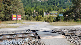
Yes, This Is a Train Station
We headed back across the highway and eventually found the “station”. There was actually a station sign on a post, a schedule on the same post, and one small bench next to the tracks. The “platform, was a narrow asphalt area next to the tracks.
We sat on the bench and waited about 15 minutes and after one earlier train came through, the train we needed to take to Morteratsch came around the corner, right on schedule. We flagged the driver, and he stopped for us to board. The train was fairly long, probably about 10 cars total. It was only a few stops to Morteratsch, and we arrived on time.
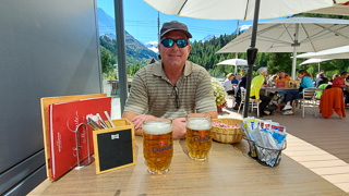
Lunch Before The Glacier Hike
After exiting the train, we saw the trail entrance to the glacier across from the station, but first, we needed some lunch. There was a large restaurant at the train stop, no wonder, since taking this trail is one of the most popular things to do near Pontresina. We found an outside table in the shade and ordered a sandwich and fries to split, along with two beers, which was probably not the best decision right before taking a long hike.
We ate the lunch, finished our beers and had our waiter fill our water bottle. With the bill paid, we walked across the train tracks and started the hike. There were quite a lot of other people on the trail, which was fairly well groomed. The hike is supposed to climb a total of 330 meters in elevation from the start up to the end at the glacier.
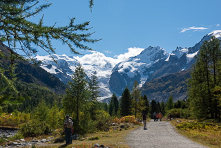
Hike to the Glacier – It is in the Background
It was not nearly as steep going uphill as the trail to the lake in Grindelwald had been, but it was longer, and we did not have any distance markers on the trail to tell us how far we had gone or how much farther we still needed to go. The entire trail is in the valley that was formed by the Morteratsch Glacier over many hundreds of years.
At the beginning of the trail, it was forested, but soon turned into just a rocky area with giant boulders, then just a rocky area with all different sized smooth rocks, worn smooth as the glacier moved through. The glacier is retreating about 18 meters a year, and has been constantly measured since 1880. There were signs along the way giving information on the glacier’s history. We stopped and read some of the information, just to take some rest breaks.
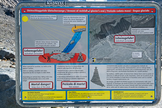
Danger Sign
The walk seemed long, but we finally made it to the end. There was a sign at the end warning of danger, yes “mortal danger”, of going onward past the sign, but there was a bridge and trail beyond the sign, so we, like everyone else, just walked past the warning sign. We did see the area that was identified as the most dangerous, and planned on staying away form there.
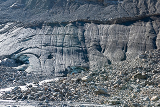
On the right of the trail was a large cliff face area that looked like a smooth rock face, but as we got closer, we saw that it was just a gigantic sheet of ice, turned brownish black by the soil. At the bottom were two different large open cave looking areas where we could see blue ice, and there was a large amount of water flowing from each of these openings into the valley stream.
The real danger area shown on the sign warned against walking up too close to the ice face, which could fail from melting ice and send large boulders and ice crashing down onto anyone who was too close. The trail that went out from the warning sign was fairly far from the ice face and only surrounded by small rocks, so we felt safe knowing the large boulders did not go this far out from the ice face if they fell.

Standing In Front of the Ice Face
We took some tripod photos, the only issue was that the sun was not at a good angle of=r direction for photos of the ice. This would have been a great thing to do this morning with the sun shining in a different direction, but it was very interesting to see none the less.
Close Up of the Ice Face
Stephanie wanted to see how cold the water was that was flowing in several small streams directly out of the glacier. She said it was really cold…ice with water flowing out of it, who would have guessed it to be that cold.
We headed back to the “safe” area by the warning sign and organized our gear for the walk back. After resting for just a bit, we started back to the train station. It was much easier and faster going back, most of the trail was downhill.
We stopped in one area to take a picture of Stephanie with a really small pine tree that looked like a small Christmas tree. We sometimes “adopt” a small tree like this while travelling, thinking it would grow into a large tree one day, and maybe we would see it if we ever returned.
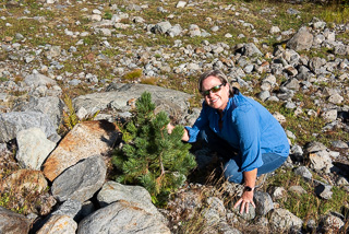
Our Adopted Tree
We started to realize that we just might be able to get back to the station before the next train arrived, saving a hour’s wait. We started to walk faster, thinking we were close to the end of the trail. However, we were not that close and by the time we arrived at the station, we discovered that we had just missed the train by a couple of minutes, even after trying to really walk fast at the end. It was just hard to tell exactly where we were when we decided to pick up the pace, and obviously, we were farther away than we thought. All we got for our efforts were tired legs.
Scenery Near The Morteratsch Train Station
Now we had to wait about 50 minutes for the next train to arrive, so we just sat on a bench and enjoyed the nice sunny weather. Our train finally arrived, and we took it back to the Pontresina train station. We had already looked on the SBB App to see when the next bus arrived at the Pontresina station to take us back up the hill to a stop near the Coop Grocery. We did not have much time before the bus was scheduled to arrive, and we were not sure where the bus stop was located at the train station. We headed one direction and saw a sign indicating the bus station was back toward the train station, it was actually past the train station back from where we had just come. We headed back in that direction and found the small bus stop just past where we had exited the train station minutes ago.
We only had to wait a couple of minutes for the bus to arrive and we boarded. The bus stopped at the top of the hill just a block from the Coop grocery. We went to the grocery store and bought bottled water, some wine and a large bottle of Coke Light for Stephanie to have for caffeine in the mornings. We needed to stock up today since the grocery is closed tomorrow, which is Sunday.
It was a lot of weight to carry back to our hotel, everything we bought was liquids, some in glass bottles, but luckily the hotel was only a few block away and all down hill! Our legs were tired from the hike, and extra tired from the quicker pace we walked to try and make the earlier train we ended up missing.
Once we arrived back at the hotel, we went upstairs to relax a bit before we went out to dinner. About an hour later, we headed back up the hill toward the Coop to go to an outside Pizzeria we had seen on the way back from the grocery earlier. The restaurant was the Nostra Pizzeria, part of the Engadinerhof Hotel.
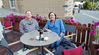
Waiting on our Dinner- Nostra Pizzeria
We got a nice table outside, and although it was a little cool, they gave blankets for our laps. We ordered a pizza, a dish of lasagna and a bottle of red wine from Montepulciano. Everything was great. There was another couple eating outside and they asked if we wanted them to take a photo of us when they saw Stephanie trying to take a selfie.
We ended up talking to them for a bit, before our dinners arrived, and then for a while after dinner. They were from Denver and we discovered they were very similar to us as far as their overall travel history and their approach to travelling. I shared our hotel check-in blunder story from yesterday and they told us they could relate to what had happened and knew how frustrated we had been, they had been through something similar in the past.
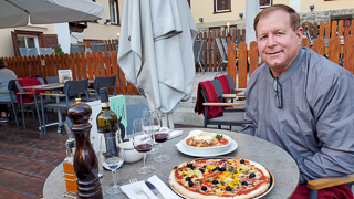
Dinner is Served
We said goodbye and we finished our wine and then we headed back to the hotel. When we were almost to our hotel when we ran into a Canadian couple we had talked to on the Glacier Express Train. We chatted with them for a while and then headed up to the room. We were tired from all of the walking today.
We relaxed with a glass of wine on our balcony that we had left to chill in our mini fridge after the grocery excursion. After finishing the glass of wine, we headed to bed at about 10:30 PM